This article was very difficult for me to translate from geological English to regular English. It seems like I was looking up every other word. Anyway, here is my attempt to explain the geology of the slice of hills just to the south of Kuching.
Karst
The swampy coastal plain of southwest Sarawak rises into a chain of hills that separate Kalimatan from the Sarawak part of Borneo. The hills are very steep, rising and falling sharply with an abrupt slope.
The hills were formed from rocks located below the surface and lava, which hardened while meandering or spurting above the ground. Another group of stones are sedimentary rocks which were formed in layers from other rocks. These are shale and sandstones. The final group were the lime stones, which was forced upwards from coral reeefs at the bottom of the sea.
Limestones, which form the Bau Serian hills, belong to the late Jurassic period (161 to 143 million years ago) to the early Cretaceous period (145-100 million years ago.) They originated during reef-building times under the sea. They were formed by colonies of various corals, which later became limestone. Individual beds of coral were thick in the centre and tapered off towards the edges. The coral reefs were later forced upward and became limestone.
The oldest known limestone is from the early Permian at the Selabor Towering Hill Southeast of Serian about 280 million years ago. The hill rises to 400 meters and contains pale grey to black limestone. The hill is very steep and contains many fossils.
In the past, geologists concentrated on antimony and gold associated with magma which forced its way into cracks in the earth and then turned into a solid rock. This occurred during the Miocene about 23-5 million years ago.
The limestone in the Bau area was first mined for the gold and antimony that forced its way up into the fissures millions of years ago. However, during modern times, the limestone was harvested for roads, cement and other construction materials.
Water
The Sungei(river) Siniawan rises near Bau, then runs across the plain and then sinks into a cave. It then runs through the limestone hills south of Jambusan where it re emerges and flows outwards to the Sungai Sarawak Kanan at Siniawan, a distance of 9 km.
There are 19 places where surface streams disappear underground. There are 28 locations where these streams re-emerge, usually at the foot of limestone hills. The streams are recharged as they pass through the hills.
The data is incomplete, and it is not known how the surface openings integrate into drainage networks.
Karst Hills and Fields
The coral reefs formed limestone. The limestone rose above the ground and became the hills. The rains came and this slightly acidic rain made holes and caves in the limestone which was once, a long time ago, coral reefs in the sea. This entire area is called karst.
There are 121 distinct blocks of limestone which rise up, with the highest peak being Brrang at 685 meters. 41 One of these blocks has only one summit. They could be described as cones, gently sloped or towers with notable cliffs.
Currently, however, there is no place where fault lines in limestone are located. Nor are there places where the up lift or tilting of limestone blocks is recorded. The orientation of the caves is also not written down.
The amount of soil removed by erosion, which causes the earth to rebound ever so slightly, and the change in sea level is also not known. Global sea-levels were 80m higher around 4 million years ago, and 20m higher around 1.2 million years ago. However, we don’t know where the ancient shorelines were, the location of the sediments or where the fossils are located.
Geologists do not have yet an accurate time table on the movement of the earth’s crust under the karst hills or how the hills moved side to side at the Bau Serian areas. In Bau-Serian, at some point in the geological past, molten rock forced itself into the limestone fissures and the molten rock hardened into igneous rock. There are many swarms of these intrusions which cut across the limestone.
The top of the exposed limestone is jagged, while the area below the soil is rounded. Sometimes, extensions from the surface rocks penetrate into caves. Broken rock fragments, from small pebbles to boulder size, accumulate at the foot of a lime stone cliffs where they could have fallen down.
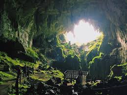
Caves
There are over 303 caves in the Serian Bau complex. Of these, 184 branch into other tunnels. Only a few of the available cave surveys include height.
There are four popularly known caves. The Tang Baan Raya cave rises to 90 meters above the floor. It stretches for 60 meters. Underground water travels for 30 meters, where it then sinks into a pool.
The Fairy Cave is 60 meters above the surrounding ground. The Sireh cave is also at 60 meters, with its main passage descending to 30 meters. The Maharajah cave is significantly higher at about 300 meters. The structure of the cave includes pathways for water to infiltrate and dissolve limestone. Layers of sedimentary rock also guide the water. The cave also slants downward and at a slope.
Cave Passages
The caves passages follow a ring like path in a circle around the hill instead of straight down or radiating outward like spokes in a wheel.
The Baan Rayan cave passage has a width from 50-100 meters, a height of ~10 meters and a length of 300 meters .It has only small entrances but two larger passes, while one forms the largest entrance. It rises diagonally, slanting upward, rather than being vertical or horizontal.
Cave Features
The features on the floor of the cave may have egg cup like holes and pinnacles. A pinnacle, in a karst cave, is a sharp limestone formations which are worn away by the slightly acidic rain.
On the wall could be scallops, notches and nest niches. Scallops look like shallow, elongated dimple or groove that line up to the direction of the water. Water moving through the cave causes the limestone to dissolve unevenly. Notches are shelves or recesses cut into the rock horizontally, while nest nitches are little alcoves built into the side of a wall.
Results of recent work(2025) in Mulu suggest ammonia generated by bat guano undergoes oxidation by microbes to form nitric acid. This nitric acid possibly erodes the walls.
Cave Sediments
Except for tiny amounts of gold found on the cave floor, very few minerals have been found since the exploration for phosphorus in 1952.
Allophane is a mineral formed by the weathering of volcanic ash. Allophane is waxy, comes in cream or pale colored layers and is soft and earthy. Its presence in caves indicates past volcanic activity.
Common types of stalactite and stalagmites are called speleothems. Most of these appear inactive. However, very little research has been performed to determine their activity.
Biology Associations
Living things associated with cave entrances where sunlight can reach are called phytokarsts. Photosynthetic strands of chlorophyll orient toward sunlight at cave entrances. The liquid in the cell also points toward light. The liquid evaporates. The resulting matrix hardens like small wavelets in sand on a beach, during an incoming tide. This mixture solidifies with the solid material pointing towards the light.
Tourism
Gunung Mulu National Park
Mount Api is famous for its razor sharp pinnnacles. Mount Benerat is known for its towering limestone main mass standing next to Mount Api and honeycombed with caves. Mount Buda is a limestone mountain with caves. Gunung Mulu is a sandstone formation surrounded by karst.
Bau Serian Karst Region
Fairy and Wind caves are contained in hills with extensive cave systems . Bukit Kapor and Bukit Serian are karst hills with small caves and outcrops.
Mount Santubong
Mount Santubong is an isolated mountain which arises from a plain. The mountain is composed of Kayan sandstone. The base of Mount Santubong has housed civilizations from many centuries.
Karst hills exist in the Kuching area, and these include Bukit Bata Selabat, Muara Tebas and Bukit Lasak.
Retak Hill
Located on the border between Sarawak and Brunei with karstic features.
From:
Laverty, Martin Caves and Karst in Southwest Sarawak in Cave and Karst Science, Vol.53, No.1, (2026)
Various sources on the internet.
Compiled by Tom McLaughlin for BorneoHistory.net