
Geology
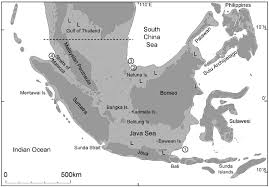
Sundaland, the landmass that included Sumatra, Malaya, Java, and Borneo, existed 50,000 years before the melting began. The land area had risen 135 meters, with most of the water tied up in ice sheets. As the ice sheets pressed down on the land to the north and south, the land on the edges bulged upward.
Southeast Asia lost the most land during the last ice age. Land area decreased by 50%, from 4.6 million km² to 2.6 million km², as it melted. Southeast Asia was the only known region in the world where people and land loss occurred at the same time.
Two rapid melt events nearly doubled the water flow, causing more land to be covered by water at ~14 thousand years ago. At 11 ka, another very rapid melting occurred, though not as large as the one at 14ka. These melt events are thought to have been caused by ice sheet collapse and the drainage of ice-dammed lakes. These two major melting events caused the two land bridges between the Malay-Thai Peninsula and Sumatra and Borneo and Palawan, Philippines to become covered with water.
The first melting caused the fringes of the islands to stabilise and create wetlands, mangrove forests and vast peat reserves. This provided food resources in the form of fish and shellfish. The population in Sundaland increased during the flooding.
Another factor was the crust, which floats on the mantle. The mantle is solid rock but thick like taffy—the Earth’s enormous heat and pressure cause it to flow. During the ice age, the crust rises because less water holds it down. More water, from melting, forces the crust back downward.
Computer models have shown that mantle thickness affects how deep the ocean floor sinks as more water sits on top. In Southeast Asia, especially around Sumatra and Sundaland, the mantle is unusually thin, which causes the land to sink further and allows more meltwater to cover Sundaland.
In summary, ice began melting 26,000 years ago, with two rapid meltings at 14,000 and 11,000 years ago, followed by a further sea-level rise and fall back 6,000-7,000 years ago. During this time, the seafloor sank, adding more water to the mix.
Humans
Humans continuously occupied the area beginning about ~70,000-~50,000 years ago. The present-day descendants of these people are the Negritos: the Orang Semang in Malaysia, the Ati and Aeta groups living in the Philippines and the people living on Andaman Island.
During the rapid melting event of 14 K, genetic evidence shows that separations occurred among the Kensiu (a population of Negroids along the Thai-Malaysian border), the Aeta (the Negroids of the Philippines), the Igorot (Austronesian-speaking peoples of the Philippines), and the Dai (a population of southern China). These people exist today. However, the people of Borneo, who I will call the Niah Cave people, did not survive. We don’t know why.
One question is why there are no Negritos in Borneo begs. Borneo most certainly had a hunter-gatherer population before the arrival of the Austronesians, a major migration southward from Taiwan. The people of Niah Caves assure that. The standard answer is that incoming migrations mixed with the Negritoes, and they were assimilated into the populations.
The flooding 14k years ago could have separated the people of Sundaland, isolating them in the Philippines and the Niah group of Borneo. However, genetic evidence from Niah has not been explored to support this connection.
The Niah people were roaming around Sundaland 47,000 years ago, as evidenced by the Deep Skull. She lived long before the melting of the ice and subsequent flooding 14,000 years ago, so we know people lived in Borneo and the Philippines at that time. They could have possibly been isolated after the major flooding event of 14,000 ka.
The other bones at Niah show very ancient remains from 30,000-40,000 years ago, another group around 12,500-7,000 years ago and still another one 3500-2200 years ago. We have people who roamed Sundaland and Borneo; then, when the great surge of 14,000 years ago, another group arrived when Borneo became isolated and then another one during the Austronesian expansion.
Palawan and Borneo were connected differently. A definite land bridge connected Borneo and Palawan, but a 13 km waterway separated them. During the height of the ice age, this water could have been very shallow, with only 3 km that rafts could cross. People could have sloshed through the water and then built rafts to cross the 3 km gap.
Models show that populations split during these rapid meltings. After 14ka years ago, rapid melting split the Sundaland population into three groups: the Orang Asli of Malaya-Thailand, the people of the Philippines, and the people who currently live on Andaman Island.
After 11 ka years ago, rapid melting caused the populations to divide into two further groups: the Austronesians, who much later migrated to Taiwan and became the founders of the vast migration and the Austroasiatics. These results suggest populations broke up after the two massive meltings at 14k and 11k.
Two minor increases in sea level, about 1-2 meters, occurred, called the Highstand, only to fall back to today’s levels. The Highstand occurred because of Earth’s rotation and land rebounding upward after the ice melted. Think of it as water moving around the globe before it settles down, like water moving back and forth in a soup bowl until it comes to rest.
One Highstand at 8.5ka occurred along the east coast of Sumatra, the west coast of Borneo, and the Malacca Strait, and then expanded outward. As the waters spread during these Highstand events, sea level rose by three meters along the coast of Borneo and the east coast of Malaysia.
A map was created which shows where evidence of the highstand areas can now be found. The resulting “Treasure map” shows that the northeast coast and central west coast of the Malay-Thai Peninsula, the east coast of Sumatra, the north coast of Java, and the southwest coast of Borneo are very likely to have areas with evidence of the advancing and then retreating highstand.
In summary, people roamed from Borneo, the Philippines, Java, and Sumatra during the Ice Age. 26,000 years ago, the ice began to melt. 14,000 years ago, there was very rapid melting and flooding and then again 11,000 years ago in Sundaland. After these rapid flooding events, people became isolated on Borneo, in the Philippines, and along the Malay-Thai border. These isolated people remain as the negroids of the Philippines and the Malay Thai border. The Borneo people became the Niah population. They have since disappeared, leaving only bones. However, no genetic evidence from the ancient bones at Niah shows they were a separate population that came from Sundaland.
Tom McLaughlin for BorneoHistory.net.
References
Chua S, Switzer AD, Li T, et al. (2021) A new Holocene sea-level record for Singapore. Holocene 31:1376–1390
Curnoe et al. Rare Late Pleistocene–early Holocene human mandibles from the Niah Caves (Sarawak, Borneo),” PLOS ONE.
Curnoe (2016), “Deep Skull from Niah Cave and the Pleistocene Peopling of Southeast Asia,” Frontiers in Ecology and Evolution.
Hie Lim Kim, Prehistoric Human Migration between Sundaland and South Asia was driven by sea level rise in Commun Biol 6, 150 (2023). https://doi.org/10.1038/s42003-023-04510-0
Tanghua Li, Sea-Level Change in Asia since the Last Glacial Maximum, in Constance Ting Chua et al Advancements in Coastal Hazards Research in Asia: Identifying Hazards, Managing Risk, Springer, forthcoming 2026- 2027